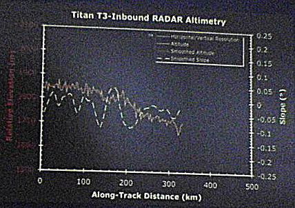
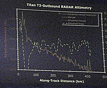
Cassini RADAR altimetry

Last week at the Lunar and Planetary Sciences, the Cassini RADAR team presented results on Titan topography obtained using the altimetry mode on their instrument as well as through radar clinometry, or shape-from-shading. Below are links to the three altimetry profiles. The numbers are a bit hard to read on the altitude side of things, but each major tick mark is 100 meters of elevation. As you can see, the outbound profile from T3 shows that there is some topography on the surface of Titan. It should be pointed out that spacific features of these altimetry profiles have not been mapped to specific surface features as of yet, so they had no idea where that sharp, 200 meter "cliff" is. Notably, all three profiles have an downward, eastward trend to them, suggesting regional slopes.
UPDATE (03/24/2005 7:10 pm): I was asked today whether the elevations here have been correlated to light and dark terrain, and the answer I can give you right now is "I don't know". I don't have the lat and lons for the altimetry swaths so where the 200 meter drop off is located is unknown to me. Well, I know where they are in general, but many of these areas have complex patterns of bright and dark terrain, particularly T3 inbound, so I can't tell how they correlate.
posted by Jason Perry at 2:42 PM
![]()
![]()


0 Comments:
Post a Comment
<< Home