Enceladus-2 Coverage Map
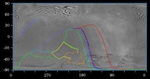
CICLOPS has released a coverage map for yesterday's encounter with Enceladus. The colored outlines represent regions on the surface of Enceladus that will be imaged by Cassini's narrow angle camera. This map does not include images taken during a "ride-along" sequence with UVIS' Gamma Orionis occultation at close approach. As you can see from this map, most of the images planned are of the southern trailing hemisphere of Enceladus, with some distant imaging of the leading hemisphere ridged plains. The highest resolution prime observations (prime observations mean that the imaging team will be controlling the orientation of the spacecraft during a block of time) will be of a region of heavily tectonically deformed terrain near 60 South, 190 West.
Note, due to unplanned changes in the orientations of the camera, the region that will be imaged could shift slightly from the outlines shown above. This mainly effects regions where the frames are much smaller than the disk, not so much the region outlined in red.
On a related subject, the JPL Cassini Website has a flyby page for this encounter. Check back here or on that page for the latest from other Cassini instruments, if and when they release products.
posted by Jason Perry at 11:40 AM
![]()
![]()


1 Comments:
I get the feeling the images returned will look similar to Europa.
Post a Comment
<< Home