New Titan Image: Titan Mosaic - East of Xanadu
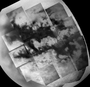
CICLOPS has released this beautiful mosaic of the H region on Titan. In fact, this may be the best mosaic ever created from spacecraft images...okay, maybe I shouldn't go that far ;) Seriously, this is a mosaic of 18 narrow-angle footprints, each with resolutions between 1 and 2 km/pixel. Behind these frames are three larger scale images, one a full-disk wide-angle image taken at the same time as these images, and the other two from the distant encounter in early July 2004.
Lots of great features can be seen in this mosaic. Above center, a dark NE-trending diffuse dark streak can be seen. This feature appears to have some eolian control, and maybe strictly an eolian feature, however, my feeling is that we have something more going on. One possibility is that this is a crater penumbra, a dust streak derived from cratering material (or from material from a "failed" meteorite, a la Tunguska). Another possibility which I favor is that this is from a geyser. We know that methane outgasses from the interior based on the lack of surface liquid and the lack of Argon-36 combined with the presence of Argon-40. This maybe an outgassing site where the dark diffuse deposit is derived from material that was carried aloft by the methane. The orientation maybe an indication of altitude (i.e. below the boundary layer at 5 km).
Other interesting features include a series of fractures south of the H, the RADAR 80-km crater with its partially dark floor in near-IR, the VIMS "palimpset", and a jumbled terrain region south east of the crater. In addition, there appear to be "tendrils" leading to the southeast from the big island in the middle. These features have led to the suggestion that surface winds in this region may not be west-east everywhere, but maybe Northwest-southeast in this region.
posted by Jason Perry at 2:04 PM
![]()
![]()


5 Comments:
Beautiful! The images of Titan keep getting better and better!
I wonder if we can extrapolate from the Huygens images to say that the light areas represent highlands, riddled with drainage channels leading down to dark, flat lowlands covered with ice-rock stones and pebbles? Or is it possible that there are also flat lowlands in the light areas and hilly ridges in the dark areas? Are there any safe generalizations that can be drawn yet?
--centsworth_II
You've mentioned the VIMS palimpset before, where is it again?
alan
1. we still think that the bright areas are either highlands or rougher areas where dark material has been washed off and deposited in lower and/or smoother dark terrains. This seems to work for the crater.
2. It is the large dark region with a bright "island" in the middle in the lower right in the mosaic. Of course it isn't really a palimpset but that was the first idea proposed by the VIMS team.
I can't help thinking that many of the features on Titan are diluvial in origin rather than eolian, i.e. due to very very large (catastrophic) floods.
That would have been my #2 explanation for the cat scratches but the way they appear near topographic broundaries doesn't seem to bear these out to be flow lines.
Post a Comment
<< Home