Titan-6 Flyby Info
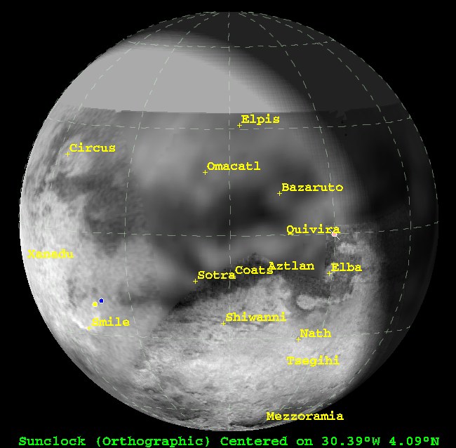
View of Titan from Cassini 2 hours prior to closest approach (sub-spacecraft point=4.09N, 30.39W). The plot was generated in GISS' Titan 24 software. The map is derived from ISS map released in March (ask for full version used here, just adds blank space north of 34N).
On Monday, August 22, Cassini will preform its seventh close encounter with Saturn's largest moon Titan. Cassini has not flown within 400,000 km of Titan since April 15, when Cassini flew within 1025 km of Titan's surface. This encounter will be a little farther away from Titan, with Cassini coming within 3670 km of the surface. This encounter is an all-CIRS flyby, with the Composite InfraRed Spectrometer instrument controling the spacecraft through the entire encounter period. The goals for the CIRS instrument include:
- Surface temperature mapping
- Vertical aerosol mapping through limb integrations
- Atmospheric temperature profiles at different latitudes
- Latitude and altitude compositional variation mapping in the near- to mid-infrared using both nadir and limb mapping
- High-resolution integration over the south pole near closest approach
Another major highlight is the magnetospheric studies. During the encounter, the magnetometer and other fields-and-particles instruments, like the RPWS, will study the exotic dayside wake/tail region of Saturn's magnetosphere and how it interacts with Titan.
With no prime coverage, ISS will be strickly in ride-along mode. Therefore, unlike the previous encounter of Titan, there will be no complex mosaics on Titan to ooo and ahh over. The ride alongs will show the region above, in the Quivira-Aztlan region. At the center of this view is an 80-km crater first seen by RADAR in February. It is surrounded by an area of bright material known as Bazaruto Facula. ISS will also acquire numerous flat-field images during CIRS slews to improve calibration.
A few facts about this flyby:
- Occurs on August 22 at 2:16am PDT
- Closest Approach Distance = 3669 km
- Relative speed WRT Titan = 6.1 km/sec
- Closest Approach Lat and lon = 58.5S, 102.7W
- Southern hemisphere pass
- Outbound flyby (sunlit inbound)
- Phase angle at T-2hours = 48.3 deg.
posted by Jason Perry at 1:29 PM
![]()
![]()


3 Comments:
Thanks for the info Jason!
I propose "Huygens Sea" for the Saturn antipodal sea, and "North Saturn Sea" and "South Saturn Sea" for the pair facing Saturn and running to ~90 degrees longitude. That's just to have something to call them... any name is fine with me!
So far nothing much suggests itself for the 270 degrees sea - "Centre Sea"? - or the ones at 320 and 340 degrees. (Nor all those Schiaparelli channels between them!)
Craig Carmichael
While I wouldn't call them seas (maybe sand dune seas ;) ), the antipodal dark region is now named Shangri-la, the southern portion of the H is now named Aztlan, and the region you call "centre sea" is Belet.
Post a Comment
<< Home