Huygens Stereo Pairs
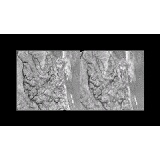
The Huygens DISR team has released five stereo pairs to show topography in the Huygens landing site region. The pairs showing the shoreline and "landing strip" region are particular impressive, with several broad plateaus "onshore".
Here are some links with commentary:
- StereoA: This view shows the drainage channel region just "onshore" in the northern bright island. The major topographic features in this image are the two plateaus in the center and lower left of each image. The drainage basin onshore appear to lie in a topographic low, with the channels running toward the top of the image to a delta (see StereoD). One of the channels even appears to run along the side of the upper plateau.
- StereoB: This view shows the eroded bright feature within the dark strait known as the "bird foot". To me, it looks like this region is pretty flat.
- StereoC: This view shows an area a few miles from the landing site within the dark terrain. Here a dark flat plain is surrounded by elevated eroded bright terrain.
- StereoD: This view shows a view similar to StereoA, though this view covers more of this particular drainage area, including the outlet. One of the key topographic feature is a tear-shaped plateau with two channels running toward the top of the frames. This view also shows that except for those two tributaries, most of the arroyos seem to be centered within a topographic valley (no surprise there).
- StereoE: This view shows the "landing strip" and an apparent exposed cryomagma dike. I'll need to look at this one a little more to see if the landing strip resembles the Europan or Tritonian double-ridge topographically as I suspect.
posted by Jason Perry at 6:59 PM
![]()
![]()


0 Comments:
Post a Comment
<< Home