Enceladus Rev 004 Coverage Map
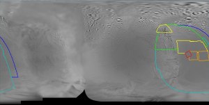
CICLOPS has released a coverage map for ISS images taken during today's Enceladus encounter. This flyby is farther east than last time, covering much of terrain seen in lower resolution imaging (~1.5km/pixel) during last month's encounter. Targets of particular interest include fractures along the eastern side of Diyar Planitia, rugged terrain south of Diyar Planitia seen in profile last month, and the curious ridges of Harran Sulci (the western end seen in the upper left cross cut by two, north-south parallel fractures).
Update: I've changed the title link for this post to the Photojournal page for this image. I guess this wasn't meant to be released today... or at least not this morning. So if you've been having problems with the title link, try it now.
Update #2: I've changed the title link back to the CICLOPS page now that it is up.
Update #3: I should note that the coverage outlined here has been trimmed by illumination angle (how far or close a location is to the sub-solar point) and emission angle (how far or close a location is to the limb), so there will be additional coverage along the edges of the outlined coverage.
posted by Jason Perry at 8:00 AM
![]()
![]()


0 Comments:
Post a Comment
<< Home