New Map of Titan
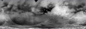
One of the images released today is my pride and joy, a map of Titan using images from before SOI, T0 (July 2004), Ta (October 2004), and Tb (December 2004). The map covers Titan's entire surface from 34 degrees North Latitude to the south pole. The map represents the best global coverage to date of Titan. Each images has been sharpened and empirically photometrically corrected to best bring out surface features (though it does a number on clouds...).
If you want to use this map for planetarium software or Titan24, keep in mind that it is cropped at around 34N. To create a map for such software, in a photo editing program like Photoshop create a blank image (either with a black or medium grey background) with a width equal to that of the non-grided map version you are using (full, half, or quarter) and a height equal to half the width. Paste this map (within the teal boundaries) on the blank image you created and make sure the bottom of the map is flush with the bottom of new image since the bottom of the released map is the south pole. You should then have a full map of Titan (even though there is no data north of 34N). You can also try pasting the RADAR data on this map, but that's beyond my skills to tutor.
posted by Jason Perry at 11:32 AM
![]()
![]()


0 Comments:
Post a Comment
<< Home