More on Today's Enceladus News
As mentioned in the last post, the ISS, CIRS, INMS, and CDA teams worked together to produce a plot showing the locations of peaks in temperature, water vapor, and dust on a polar projection map of the surface of Encleladus. At first glance, the peaks for INMS and CDA would seem to suggest that the circumpolar ring of folded, tectonic terrain may be the source of the vapor and dust. However, neither peak is located within the region of warm ice seen by CIRS, an area that would be more likely to see significant activity. Numerical simulations by the CDA team, combining the timings of the CDA and INMS peaks, suggest that both the vapor and the dust are connected, have the same source, and are distributed across a small region on the surface near the south pole. The source is not impact-generated dust which would be uniform across the surface, as originally thought.
So what does this say about how the vapor and dust form? Three possible scenarios were presented at the press conference. The first scenario sugggests that sublimation of ice within warm, 140 Kelvin fractures, could produce the vapor. This would fit with the lack of a visible plume by ISS but may not fit with the dust detections. The dust could possibly be produced by condensing vapor, but this may not be supported by the CDA data. The second scenario suggests that vapor and dust are generated by a plume that eruptions along the tiger stripe fractures. This would easily allow both vapor and dust to be ejected to the altitudes seen by INMS and CDA but thus far, no plume has been observed by ISS. The third scenario suggests that vapor and dust could be produced by sublimation along cryolava flow fronts. While some of the terrain between the tiger stripes looks like a lava flow, the distribution of crystalline ice seen by VIMS and the blue-green course-grained ice seen by ISS have been observed along the fractures, not within the flows, so it seems that this scenario may not fit the current conditions. My only complaint about the graphic is that it assumes that the interior is made of only water, not water mixed with ammonia, which would lower the melting point of water. I don't see why you can't have the plume scenario with a sub-surface layer of water mixed with ammonia (just to answer Jerry's comment about the required temperatures).
So which scenario are scientists leaning toward? Considering current conditions and what we have observed geologically, I would definitely lean toward the second scenario for a few reasons. While we have not observed a plume, there are some indications that activity at Enceladus may be quite variable. UVIS detected a large increase in the amount of oxygen in the E ring early last year. Considering that the primary source of the E ring is now found to be the south polar vents, it seems reasonable that such a mass increase could have been due to a major eruption on Enceladus. Such variability with time may be difficult to achieve with the first scenario. Plus, one has to consider how you get dust particles along with the vapor in a purely sublimation scenario. You can do it, but I find it hard to believe you can do it with this much dust. The third scenario could partially fit, the terrain between the tiger stripes does look an awful lot like a lava flow. However, the distribution of course-grained ice, the sublimation problem mentioned in the first scenario, and the lack of ammonia detected on the surface seems to suggest that the cyroflow sublimation model is not the best fit. So I would consider the second model, the plume model, as the best fit to the data.
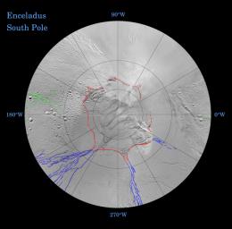
The ISS team also released preliminary tectonic maps showing the distribution of longitudinal and latitudinal fractures on the surface. These maps show that many of the fractures on Enceladus follow longitude and latitude lines, perhaps caused by the changing shape of Enceladus as the tidal stresses on Enceladus wax and wane. In addition these maps outline a wavy, circumpolar ring of fractures at around 55 degrees South latitude, marked by Y-shaped discontinuities that lead into fracture systems that lie along lines of longitude. Such fractures could be caused by "hoop stresses", formed during periods when the equator expanded, perhaps as Enceladus was sped up. Unmarked versions of these maps of the north and south polar region show the marked difference between the two polar terrains. The north polar region is heavily cratered and is the oldest region on the surface of Enceladus. The south polar region is very young with very few craters south of 55 degrees south, and none (larger than 200 meters) south of 70 degrees south. Note the hooks at the end of the tiger stripe fractures.
More Enceladus to come.
posted by Jason Perry at 9:44 AM
![]()
![]()


2 Comments:
Thanks, Jason
It is worth noting that the second scenario requires subsurface temperatures of at least 270deg K; with both tidal and radiogenic heating.
Not necessarily. A water-ammonia eutectic can be liquid down to 173K, and it's possible to throw in some other stuff and get the freezing point even lower. I'm guessing we haven't seen much mention of ammonia not because folks think it's not there, but because we're mostly getting results from the Cassini instrument teams and there's not much direct evidence for ammonia from Cassini. The indirect evidence is awfully suggestive, though it's certainly true it could turn out that something cooler/weirder than ammonia is involved.
Post a Comment
<< Home