Friday, June 03, 2005

Updated Enceladus Article on Wikipedia

I have gone ahead and extensively updated the Enceladus article, including information from Cassini as well as incorporating images. The original article was largely based on Calvin Hamilton's website with a few minor Cassini related updates, like on the atmosphere. Feel free to check it out and of course check my spelling and grammar ;)

Rev09 Non-Targeted Encounters


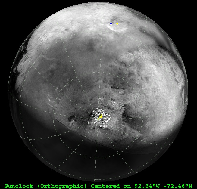
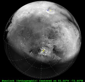
Graphic showing the geometry of Titan's surface features 9.5 hours before Closest approach during Monday's non-targeted flyby.

Cassini is now in its tenth orbit around Saturn, refered to within the project as Rev 09. You may recall that the first and second revolutions where replaced by three orbits (A, B, and C) thanks to the Huygens Doppler Shift correction. We are still within the ring occultation phase of the Cassini mission, so the satellites don't get much coverage during this orbit. There however will be a couple of important non-targeted opportunities during this revolution. First up will be Titan. On Monday, Cassini will come within a half a million kilometers of Titan, allowing for images with resolutions approaching 2.5 km/pixel, comparable to those taken during the last major non-targeted opportunity shortly after the Saturn Orbit Insertion burn (the encounter had been dubbed T0). Like that first encounter, this flyby will highlight the south polar region of Titan. Thanks to the northward climb of the sun in Titan's sky, this maybe one of our last best looks at this region. The last time we looked here, there was a field of convective cumulus clouds shrouding the south pole (as you can see in the graphic above which use a map that contains images that were taken on that flyby). Clouds, however, have been noticibly absent from Titan's skies for the last six months, and it is hoped by Titan surface scientists (like myself), that the south pole will remain cloud-free so that we can have at least one unobscured look at this region. After this flyby, there can be clouds galore. This flyby will also provide the best look thus far of the southern Xanadu region. The central and southern regions of Xanadu will be poorly covered during the Cassini nominal mission, so this maybe one of our best looks at this region for the entire mission.

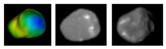
The other non-targeted flyby on this orbit occurs after periapsis, on Thursday. The target this time will be the chaotic moon Hyperion. This will be our best look so far of this potato moon. A graphic showing the geometry of Hyperion near close approach is available. Cassini will come within 166,000 km of Hyperion early next Saturday, allowing for images with resolutions below 1 km/pixel. Such observations could be a tremendous boon for understanding Hyperion geology, spin state, and history, and will be a great primer for the targeted flyby of Hyperion in September. During that flyby, Cassini will come within 500 km of that satellite.

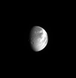
Other non-targeted encounters for this orbit include a 230,000 km encounter with Dione (which would show Dione's south polar region as well as Padua and Palantine Lineas).

Raw Images of the Day

Since my last update on Monday, there have been a few new satellite-related raw images posted. Not many admittedly, but a few interesting ones.

Wednesday, June 01, 2005

NASA Strategic Roadmap

Last week, NASA released their Strategic Roadmaps for near- to mid-term exploration of the solar system (out to 2035). The document entitled "The Solar System Exploration Strategic Roadmap" is most relevant to this blog. This roadmaps highlights three classes of missions: large, Flagship missions where the cost scale is in the billion dollars or more area, mid-priced New Frontiers missions, and relatively cheap Discovery missions. Very little is discussed for the New Frontiers and Discovery class since these are often competitive programs, however a copy of the New Horizons mission has been mentioned in numerous forums. It is possible that such a mission, on route to the Kuiper Belt, might flyby Uranus during solstice. In the Flagship-class, numerous outer solar system missions are highlighted. The first, scheduled for the 2005-2015 time frame, is the Europa Geophysical Observer, a "reimagining" of the cancelled Europa Orbiter mission that would orbit Europa for 30 days searching for a subsurface ocean and characterizing the geophysical properties of the ice shell. Hopefully such a mission would also explore interesting moons like Io during the probe's two year Jupiter-orbital phase before entering Europa orbit.

In the second decade envisioned, 2015-2025, the roadmap offers two choices: a Titan Explorer and a Venus Surface Explorer. The Titan Explorer is envisioned as an aerial platform that would have access to the surface, providing high-spatial and spectral resolution of the surface, as well as exploring Titan's atmosphere in-situ. Access to the surface is also envisioned. Numerous options are given for the third decade of the roadmap, 2025-2035. Most relevant are a Europa lander and a Neptune System mission. The Europa lander would study the immediate sub-surface in search of astrobiologically-meaningful materials. The Neptune System mission would encompase numerous instrument platforms, including a Neptune orbiter, Neptunian atmospheric probes, and a Triton lander.

Amalthea: The Rubble Pile


Using results from the Galileo flyby of Amalthea in Nov. 2002, scientists have pieced together the density of this inner satellite of Jupiter. Rather than finding a rocky body that was expected from the density trend within the much larger Galilean satellites (innermost Io is densest while outermost Callisto is the least dense of the four), doppler shift data from the Galileo flyby revealed a very porous world with a density less than that of water. Even assuming a reasonable porosity that is in line with other worlds of its size, Amalthea must have a significant amount of ice. Such a result is inconsistent with the idea that a hot young Jupiter burned away water from the inner satellites like Io and Europa (though considered an icy body by some, its watery shell only constitutes the outer 100 km of Europa while the rest is silicates and iron). Either our understanding of the early period of Jupiter's history is incorrect (meaning Io and Europa lost their water through other means), or Amalthea formed elsewhere in the Jovian system or even outside the system itself.

The image above (a higher resolution version is linked), shows three views of Amalthea. The first is a shape model of Amalthea with escape velocity color coded (blue on the anti-Jovian end represents 1 m/sec while reds on the leading side represent 90 m/sec). The other two views include a mosaic of Voyager and Galileo images of the anti-Jovian hemisphere (middle) and a view of the leading hemisphere from Galileo (right). The bright spots on this satellite have intrigued scientists since the Voyager flybys. Given this result, it is quite possible that the spots maybe water ice exposed from beneath a mantling of sulfur from Io.

New Dione Image: Dramatic Moon


CICLOPS today released this processed view of Saturn's moon Dione taken in late April. This view shows several of Dione's wispy markings including Palantine (must not say Palpantine) Linea running to the southwest and Carthage Linea running to the west. These markings were found in December to be bands of fractured crust with the bright markings coming from the bright walls of the graben. Several central peak craters are also visible in this view near the terminator (I think that's Dido at the 8 o'clock position).

Resolution on this image is 17 km/pixel.

Tuesday, May 31, 2005

Raw Images of the Week