Friday, March 25, 2005

Titan-4 Mission Description and other products

T4 medium range
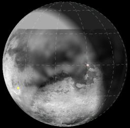
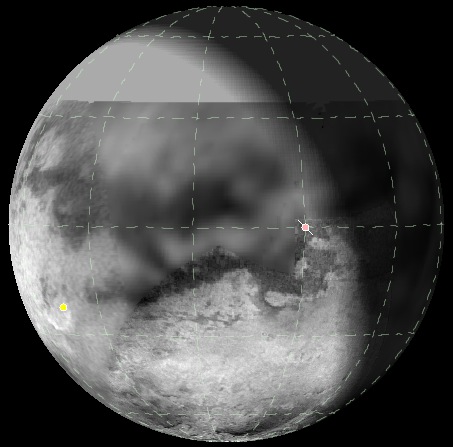
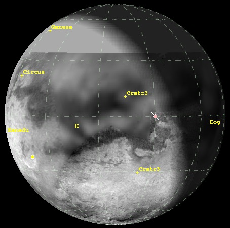
View of Titan from Cassini during ISS' medium range coverage mapping (sub-spacecraft point=1.1N, 21.3W). The orange point marks the sub-Saturnian point and the yellow point marks the sub-Solar point. The plot was generated in GISS' Titan 24 software. The map is derived from ISS map released earlier this month (ask for full version used here, just adds blank space north of 34N). The full version of above plot is available (as well as one with surface feature labels; cratr2 is the 80-km wide crater found by RADAR, Cratr3 is a dark ring found by ISS during T0). the data for plot was obtained from Mission description document.

JPL has released the mission description for next week's Titan flyby over the sub-Saturnian hemisphere. The usual goodies are include like instrument goals for the flyby, timeline of events, and the playback table to you (and I) can have a reasonable idea of when the data will be played back. From the looks of it, the playback for this flyby will take place during mid-morning here in Tucson so I don't have to stay up and have to process images till 3 in the morning like some of the last few flybys.
Here are some highlights in the flyby goals:
  • ISS will image the northern sub-Saturnian hemisphere of Titan with medium resolution narrow angle imaging combined with wide angle camera photometry. ISS will also have some high resolution imaging specifically targeting the surface covered in T3 closest approach RADAR SAR. From the screen cap on page 5, it looks like ISS may capture Saturn over Titan's limb in a CIRS ride-along.
  • UVIS observations will map airglow emission lines from Nitrogen and Carbon and measure reflected sunlight from Titan's haze to study the properties of haze particles.
  • CIRS observations will include limb profiles to measure vertical profiles in temperature and to look for aerosols, as well as nadir observations to measure the distribution of Carbon monoxide, Hydrogen cyanide, and methane.
  • RPWS will continue to search for lightning as well as understanding the plasma interactions with Titan's atmosphere and the magnetosphere in Titan's vicinity.
  • VIMS will carry out observations of Titan's cloud features (if they show up this orbit...). VIMS will also carry out compositional mapping of Titan's northern sub-Saturnian hemisphere.
  • RADAR will preform radiometry and scatterometry observations complimentary to those carried out on Ta.
For the curious, ISS' medium resolution images start playing back at around 10:30 am MST next Friday. Not sure how that will translate to when they will show up on the JPL raw images page. Also, it seems that the JPL Raw images page has some problems with image links during a real-time stream, so you may have similar problems next week.

T4 Closest Approach is on March 31 at 2:18 pm MST.

UPDATE: added plot above.

Cassini Significant Events for 03/17/05 - 03/23/05

The Cassini update for this week. Find out what the spacecraft did this week. One interesting note that even I did not know and I applaud is that the Mission Planning team is considering lowering the close approach distance to Tethys for the September 24 distant flyby, currently slated to have a distance of 33,000 km. This would be a significant boon to Tethys science, but may impact support teams who have to deliver a new reference trajectory as well as Saturn atmospheric observations. This update mentions a number of meetings on this issue but no resolution is mentioned. Here's hoping it is approved!

Solar System Simulator has a view of Tethys an hour or so before C/A on September 24.

Happy Titan Day

Happy Titan Day everyone!! Okay, not an official holiday, at least not for the next hundred years, but today is the 350th Anniversary of Christiaan Huygens' discovery of Titan. So drink some Titan ale and have some Xanadu Bread and enjoy the day.

UPDATE: The Astronomy Picture of the Day website is celebrating Titan Day by showing an image of the telescope lens used by Huygens to discover Titan, or as Huygens called it "Luna Saturni". They also have a great link to a Dutch website (in English) describing the circumstances of the discovery and the means by which Huygens announced it.

New Janus Image: Janus' craters


CICLOPS has released another processed view of Janus, a small, inner satellite of Saturn. This view reveals two good-sized craters near the terminator. This image was taken last month and has a resolution of 7 km/pixel.

Thursday, March 24, 2005

Enceladus and Image Resolution

A few weeks ago, in response to a post I made regarding raw images from this month's Enceladus flyby, Gsnorgathon asked, "whether we'll be seeing better than 25m/px resolution later in the mission"? Good question, I had no idea at the time. Anyways, a few days, at a colloquium given by Zibi Turtle here at the University of Arizona mentioned that we will probably not get better images than 25 m/pixel, despite coming within 100 km of Enceladus in March 2008 (which would yield sub-meter resolution images if ISS took images at C/A). Range-to-target smear (smear caused by the spacecraft motion to and from a target during the exposure) not withstand, there is another problem which I hadn't considered. The E-ring. Enceladus' orbit is smack dab in the middle of the densest part of the E-ring, and just as before and after the SOI burn, Cassini needs to turn close to C/A so that the high-gain antenna protects the spacecraft from E-ring particles. Since Cassini doesn't have a scan-platform and the camera and antenna boresights are perpendicular to each other, the camera can't point at Enceladus and protect itself from E-ring particles at the same time.

LPSC Notes Part I

As you can probably imagine, I took quite a lot of notes at LPSC. My original plan was to have all my notes on my PDA that would make for transferring to my blog a fairly painless process. Then the charger for my PDA died (thank gob for the CompUSA nearby). Regardless, I am now having to re-type my notes from my original handwriting, which even I can barely read.
Over the last few days, other news site have posted reports from LPSC so I will refrain from re-treading where others have posted. It wastes both my time and your time. And since other news sites, like planetary.org pretty effectively covered some Cassini talks, this leaves me with not as big of a task.
I am posting these notes in raw format. Meaning, very little re-writing from my notebook (or in some cases, my camera), to this blog. I admit it, I am a lazy person by nature, ask anyone I know, and I don't feel like writing a huge story. I apologize in advance for those who were expecting nicely written reports like those posted by Emily Lakdawalla over at planetary.org, but I just don't have it in me today. Maybe I will re-write this tomorrow, I don't know. Today, I will cover the first day of talks, from last Wednesday, and tomorrow I will post notes from the second day of talks, from last Thursday.
  • LeBreton - Huygens results
    • spin reversed at T0 + 9.5 min. SCET
    • 93.65 +/- 0.25 K temperature at the surface
  • M. Tomasko - DISR results
    • Earliest Discernable surface features - 40-45 km
    • Sun Tracker lost track @ 40 km due to probe motions
    • Bottom 20 km, wind speed dropped far below expectations
    • Several Degrees of swing and tilt seen all the way to the surface
    • Drainage channels 40 meters wide
    • 50% linear polarization @ 500 nm @ 140 km
    • Haze particles larger than expected (monomer size ~ 0.05 microns in haze)
    • number of monomers in haze ~ many hundreds
    • 5% methane mixing ratio at 20 meters altitude
    • Specta shows water ice absorbtion at 1.5-1.6 microns
    • Upward looking spectrometer indicates that the sky is brightest at 50 km
    • Edge of bright terrain - steep slope - 100 meter tall scarp
  • R. Lorenz - SSP results
    • Sounder - speed of sound ~ 180 m/s
  • H. Niemann - GCMS results
    • Loss of ion source 5 ~ failed to operate after T0 + 23m30s ~ caused loss of seperation between CO and N2
    • Mass 96 enrichment?
    • Trace amount of ethane detected at surface
    • Methane mixing ratio ~ 5.4%
    • 14N/15N ~ 114
    • 12C/13C ~ 83
    • Argon-40 mixing ratio ~ 5x10^-5
  • Cassini RADAR results
    • Cat scratches - 2-3 km seperation - 100s km in length - interpreted as longitudinal dunes
    • Evidence for regional slopes - flow to east
  • Cassini INMS results
    • constant, isothermal temperature ~ 143 +/- 3 K
    • Ch4 mole fraction ~ 2.7 +/- 0.1% @ 1174 km
    • 12C/13C ~ 96.6
    • 14N/15N ~ 187-216
    • Argon-40 ~ 8.6 ppm

Raw Images of the Day

New Enceladus Image: Stressed-out Enceladus

HIRES anaglyph
This is one of three anaglyphs released today by CICLOPS. This view shows one of the highest resolution views of Enceladus in stereo. The resolution of the red image is 30 m/pixel. On the left hand side, a region of deformed terrain can be seen, manifested in a series of parallel ridges. Fractures can be seen elsewhere in the image, including a canyon on the right side.

New Enceladus Image: Sliced-up Craters


This is the second of three anaglyphs released by CICLOPS today of Enceladus. This view shows numerous craters being heavily modifed by tectonic forces. The crater in the upper right in particular shows evidence of fracture in the upper few hundred meters of the crust revealing bright material below. The crater just above center right appear to be split in two by "Alan Wrench Chasma". Speaking of chasma, perhaps the most striking stereo features are the two sets of horst and graben terrain seen along the top (same sets of horst and graben seen near the bottom of a color image released last week) and just above center. Note the raised topography on the south side of the chasma near the top and the raised rims of some craters (like the one near bottom center).

BTW, these anaglyphs require red-blue 3D glasses to see the topography.

New Enceladus Image: Transition on Enceladus


CICLOPS has released three new stereo views of Enceladus using images taken during Cassini's most recent flyby of that moon a few weeks ago. This particular view shows the transition from cratered terrain to grooved terrain, demarcated by a sharp, westward-facing cliff that runs generally north-south just left of center. The craters in the cratered terrain have been heavily deformed, both by fracturing, indicating a high amount of stress on the lithosphere of Enceladus in this region, and by viscous relaxation (making craters appear smooth and shallow), perhaps indicating a higher heat flow in this part of Enceladus. To the west of the cliff, the surface is much younger with far fewer craters. This region is characterized by parallel sets of grooves and ridges. On the far left, you can see a snipet of the wrinkled terrain characteristic of Diyar Planitia. Cross-cutting all of this terrain, is a sharp fracture that runs north-south just east of the cliff in the crater terrain, then turns to the southwest, cutting across the cliff and grooved terrain. This indicates that this fracture is one of the youngest features in this image.

New Janus Image: Janus Rides the Rings


CICLOPS has released this newly processed view of the inner satellite Janus taken last month. This is one of the best views of this small satellite to date. Some interesting topography near the terminator, not sure what to make of it.

Wednesday, March 23, 2005

New Dione Image: Far-off Fractures


CICLOPS has released a new view of Saturn's mid-sized icy satellite Dione. This view shows the "Amata" region of fractures stretching from the limb to the terminator. This view was taken last month shortly after the first close flyby of Enceladus and has a scale of 8 km/pixel.

Tuesday, March 22, 2005

Planetary Society: Something Funny Is Going on at Iapetus and Enceladus

The Planetary Society has another article posted on their website covering last week's Lunar and Planetary Sciences Conference, this time covering Saturn's other satellites. The two moons that stole the show were Iapetus and Enceladus, though images from ISS of Enceladus were not presented. Certainly a good read, though I cover quite a bit of this information in my earlier "LPSC Initial Notes" post below. Oh well, you can always say you heard it here first ;)

Thanks to decepticon over at the Unmanned Spaceflight forum (fomerly the MER Forum) for the heads up.

Note to any members of the IAU who may be reading this: PLEASE slap a name on the equatorial ridge of Iapetus. If I hear "belly band" one more time...

Cassini RADAR altimetry


Last week at the Lunar and Planetary Sciences, the Cassini RADAR team presented results on Titan topography obtained using the altimetry mode on their instrument as well as through radar clinometry, or shape-from-shading. Below are links to the three altimetry profiles. The numbers are a bit hard to read on the altitude side of things, but each major tick mark is 100 meters of elevation. As you can see, the outbound profile from T3 shows that there is some topography on the surface of Titan. It should be pointed out that spacific features of these altimetry profiles have not been mapped to specific surface features as of yet, so they had no idea where that sharp, 200 meter "cliff" is. Notably, all three profiles have an downward, eastward trend to them, suggesting regional slopes.
UPDATE (03/24/2005 7:10 pm): I was asked today whether the elevations here have been correlated to light and dark terrain, and the answer I can give you right now is "I don't know". I don't have the lat and lons for the altimetry swaths so where the 200 meter drop off is located is unknown to me. Well, I know where they are in general, but many of these areas have complex patterns of bright and dark terrain, particularly T3 inbound, so I can't tell how they correlate.

Raw Images...of the day

More raw images hot of the presses:
  • Iapetus...one day later. Iapetus rotates so slowly (once every 79 days), that we are just now reaching the 1 day point since the New Year's Eve flyby by Cassini that gaves us our best view ever of this oddball (well, it is so far from being a spherical, can it really be called an odd "ball"?). This is just about the saw area that was lit during that encounter. If you squint really hard, you can just barely make out the equatorial ridge.
  • Tiny Mimas
  • Rhea, behind the rings

Monday, March 21, 2005

New Hyperion Raw image

I usually try to highlight several raw images at a time, but I can't pass up new view of worlds not seen before very well. This particular view, linked in the title of this post, shows a large crater or valley edge-on along the terminator. It is views like these that make me wonder whether Hyperion really is a shattered remnant of a once "proud" moon...

We shall certainly see come September.

Update: Here is another one from Saturday. And another from last Thursday. and finally from last Wednesday.

Nature.com article on Enceladus' atmosphere

Nature.com has a few more details on Enceladus' atmosphere in an article by Mark Peplow. Apparently, the magnetometer is able to constrain on of the constinuents as water vapor. In addition, the article constrains the pressure as being similar to that of the atmospheres found around Europa, Ganymede, and Callisto, or 10^-10 bar.

Astrobiology Magazine: Comparing the Triad of Great Moons

As a followup to one of my first posts on this blog, Astrobiology Magazine has posted the third part of a four part series of an edited transcript from a talk Jonathan Lunine gave at the NASA Director's Telecon in late January. In this part, Titan uses a very similar argument used with the Venus/Earth/Mars "family" with Titan, Ganymede, and Callisto, moons with similar radii and densities (and presumably similar formation scenarios) but with vastly different histories.

For those who can't stand edited transcripts, if you have RealPlayer, why not listen to the talk? Or for those who don't have the time to read the edited transcript and just want the nuts and bolts, read my summary.

Thanks to imran at the MER forum for the heads up.

Update 03/25/05: The talk now appears to be offline. Sorry to all those who didn't get a chance to watch it.

New Cassini image: Titan and Dione


On Thursday, CICLOPS released this view of Titan (lower left) and Dione (upper right) as they appeared in the same narrow angle frame last month shortly after the T3 flyby of Titan. Clearly visible in this image is the sharpness of Cassini's view of Dione with its wispy fractures and impact basins and the fuzzy Titan, thanks to its extensive atmosphere.

New Rhea Image: Color on Rhea?


CICLOPS has released this false-color view of a crescent of Rhea. Tirawa impact basin can be seen in the upper right. Notable in this image is the slight color variations between the poles of Rhea and the equator, a similar effect as that seen on Ganymede.

New Cassini Movie: Mimas Occults Janus


Following up on an earlier post, CICLOPS has released a new movie showing Mimas, with Herschel clearly visible, occulting the small, inner satellite Janus, a few week ago. It should be noted that some frames were interpolated, rather than actually observed by Cassini to allow for a smooth video. Mimas is nearing its closeup coming next month when Cassini flies within 85,000 km of the small, cratered satellite.

Sunday, March 20, 2005

Raw Images of the Week

Not posting much in a week, I am not seriously behind in posting info on raw images that have showed up on the JPL Raw images page in the last week...

Planetary Society Article on LPSC Titan results

The Planetary Society has an article on Titan results presented at last week's Lunar and Planetary Sciences Conference. A very informative article for those who weren't there (and a good recap for those like me who were). A word of caution on the parabola RADAR thinks they saw around the 80-km wide crater seen last month. ISS will be viewing that crater on March 31 and will see if that parabola is real (since it was cropped by the narrow extent of the SAR swath). Preliminary images are not encouraging for the RADAR team's interpretation.

New Hyperion Image: Hyperion Hoopla


CICLOPS released Friday several views of the chaotically rotating Hyperion taken between October and February. These views show several new details not seen before on this 266-km wide moon, such as a 80-km wide crater seen in several of the more recent views. Cassini will get a far better view of this oddball in September.

Correlations between Huygens and ISS images

Rene Pascal has posted an informative look at correlating features seen by Huygens and features seen by Cassini ISS. While I disagree with his conclusions, I highly doubt that the higher altitude height estimates for DISR images are off by 250%, the exercise is instructive. Knowing how the images presented from ISS were constructed, I find it highly plausable that the "Huygens scale" is accurate and corresponds well with what we have seen in ISS images. Height measurements for Huygens images may only need to be off by as much as 10-20%.

LPSC Initial Notes

I got back from the Lunar and Planetary Sciences Conference in Houston yesterday. I took quite a few notes but it may take a while for the lot of them to be posted here. So expect some notes to be posted each day this week. However, here are a few key highlights I thought I should post now:
  • Both the Magnetometer and MIMI observed an atmosphere at Enceladus, but UVIS did not (another instrument that won't be revealed here just also detected gases in the Enceladus region). MIMI and the Magnetometer detected an interaction between Saturn's magnetosphere and Enceladus consistent with a "dense" atmosphere 2 Enceladean radii in extent. The magnetometer observations might also be consistent with a higher production of ions in Enceladus' environment. UVIS did not detect an atmosphere at Enceladus, putting an upper limit on any atmosphere of 2-3 x 10^8 atom/cm^3 in density. Also, no oxygen emission was seen at Enceladus by UVIS.
  • The CIRS and UVIS presentations on Iapetus suggested another possible formation mechanism for the dark terrain. Rather than dark material being deposited on the surface, the two teams suggested that the lack of water ice could be due to the removal of bright ice material from Cassini Regio, leaving behind the dark, carbonacous, fluffy material. Interestingly, Phoebe, which according to some theories is the source of the Iapetus' dark material, is more similar to Iapetus' bright terrain in composition than the dark terrain. For ISS, the north polar bright terrain was seen to be lower in altitude in MOLA-like DEM maps than the dark terrain though the map still needed the proper tri-axial ellipsoid solution.
  • Peter Lanagan presented a formation model for the cryolava flow seen near the "runway" feature seen in Huygens DISR images.
  • Enceladus' density is the highest of the inner icy satellites, third of the Saturnian satellites with only Titan and Phoebe having greater densities. The density of Enceladus is 1.6 g/cm^3.
  • The near surface winds detected by Huygens were very weak, on the order of 1-2 m/s and in fact, DISR images indicate that Huygens moved roughly eastward until around 3 km altitude when Huygens swung northward and in fact a little westward. Thus, at the lowest scale height, zonal winds are weaker than rotation. Given this information, the poles are warmer during summer in a narrow zone near the surface. This is not surprising given the level of storm activity near the poles during summer.
  • RADAR radiometry detected a gradient in dielectric constant from north (~2.1) to south (~1.6) indicating an increase in organic material from north to south. RADAR scatterometry demonstrated that optically dark (radar dark) materials were warmer than optically bright (radar bright) materials. This pattern breaks down though in the "French Coast" region of Southwest Xanadu, which is optically bright but warmer in radar scatterometry. In RADAR SAR, the team is interpreting the "cat scratches" as longitudinal dunes, long dune forms that are parallel to the prevailing wind direction. These are often seen in the Sahara desert and in the Simpson desert in Australia on Earth. Given their prevalence on dark material, it is quite possible that dark material are not bodies of liquid, but seas of sand. Finally, the RADAR team is interpreting many of the round features seen in Ta as cryovolcanic features such as lava domes or calderas. In RADAR altimetry, much more relief was detected, including a 200 meter drop over 2 km and 400 more meter downward slope over another 300 km.
  • GCMS detected Argon-40, Ethane (C2H6), Ethanedinitrile (C2N2), Acetylene (C2H2), and Carbon Dioxide on Titan's surface.