Friday, August 19, 2005

T6 Coverage Plot


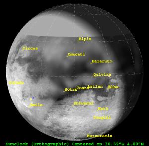
CICLOPS has released a coverage plot showing the regions that will be imaged by ISS during Monday's flyby of Titan. This is the same region that was covered during the last two Titan flybys in March and April. Since ISS doesn't have prime coverage on this flyby, there are no complex mosaics for this encounter because higher resolution images would be smeared by spacecraft motion during CIRS slews. ISS will be taking advantage of that by taking flat-field images (images that show no discernable surface features, but clearly show camera artifacts). The best images taken by Cassini during T6 will be of a newly named feature called Bazaruto Facula, a bright region thought to consist of icy ejecta from an 80-km crater at the center of the feature. The southernmost portions of the highest resolution images will show the bright region known as Quivira. The areas of larger coverage (2-5 km/pixel), cover much of the "H" (southern portion of the H now known as Aztlan) and northern Tsegihi.

See the T6 post below for more information on this encounter.

Thursday, August 18, 2005

Titan-6 Flyby Info


View of Titan from Cassini 2 hours prior to closest approach (sub-spacecraft point=4.09N, 30.39W). The plot was generated in GISS' Titan 24 software. The map is derived from ISS map released in March (ask for full version used here, just adds blank space north of 34N).

On Monday, August 22, Cassini will preform its seventh close encounter with Saturn's largest moon Titan. Cassini has not flown within 400,000 km of Titan since April 15, when Cassini flew within 1025 km of Titan's surface. This encounter will be a little farther away from Titan, with Cassini coming within 3670 km of the surface. This encounter is an all-CIRS flyby, with the Composite InfraRed Spectrometer instrument controling the spacecraft through the entire encounter period. The goals for the CIRS instrument include:
  • Surface temperature mapping
  • Vertical aerosol mapping through limb integrations
  • Atmospheric temperature profiles at different latitudes
  • Latitude and altitude compositional variation mapping in the near- to mid-infrared using both nadir and limb mapping
  • High-resolution integration over the south pole near closest approach
With so many different types of integrations, CIRS will be able to show off its versatility.

Another major highlight is the magnetospheric studies. During the encounter, the magnetometer and other fields-and-particles instruments, like the RPWS, will study the exotic dayside wake/tail region of Saturn's magnetosphere and how it interacts with Titan.

With no prime coverage, ISS will be strickly in ride-along mode. Therefore, unlike the previous encounter of Titan, there will be no complex mosaics on Titan to ooo and ahh over. The ride alongs will show the region above, in the Quivira-Aztlan region. At the center of this view is an 80-km crater first seen by RADAR in February. It is surrounded by an area of bright material known as Bazaruto Facula. ISS will also acquire numerous flat-field images during CIRS slews to improve calibration.

A few facts about this flyby:
  • Occurs on August 22 at 2:16am PDT
  • Closest Approach Distance = 3669 km
  • Relative speed WRT Titan = 6.1 km/sec
  • Closest Approach Lat and lon = 58.5S, 102.7W
  • Southern hemisphere pass
  • Outbound flyby (sunlit inbound)
  • Phase angle at T-2hours = 48.3 deg.
Data playback begins at 10:05 pm PDT on August 22 and continues until 07:05 am PDT the next day. Based on prior experience, it appears that images start showing up on the JPL raw images page over an hour period about 10 hours after the start of the playback. This would mean that images will show up on the raw images page at around 8 am PDT August 23.

Rev13 Hyperion Images


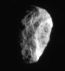
New images of Hyperion, taken over the last couple of days, are now posted on the JPL Raw images page. These images were taken from four times the distance of the images taken in June, but are not saturated like those images, allowing for better color information to be derived. Of course, this is but a taste of what is to come, as next month, on September 25, Cassini will fly within 500 km of the surface of Hyperion, allowing for the highest resolution coverage of Hyperion for the Cassini nominal mission. Images taken in June revealed a segregation of bright and dark material, with dark material occupying crater floors. They also revealed a fascinating array of crater morphologies, which maybe related to the effects of Titan on Hyperion's ability to re-accrete material from impacts on its surface. A rather "normal" looking simple crater can be seen in the image above, however, near the lower left.

Many of the images taken during orbit 13 have looked at areas made famous by Voyager. This region is dominated by a tall scarp known as Bond-Lassell Dorsum, which maybe the remnants of a large impact on Hyperion.

UPDATE: 08/18/2005 2:15 pm: Emily Lakdawalla has additional information on these images as well as an animated gif showing the sequence of images taken during this distant encounter on her Planetary Society Blog.

New Epimetheus Image: Looking Down on Epimetheus


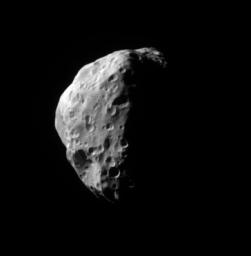
CICLOPS has released this view of Epimetheus taken on July 14, shortly after the Enceladus flyby. This images was taken from a distance of 87,000 km and has a resolution of 520 m/pixel, making this one of the highest resolution views of this small world. Epimetheus is covered in craters with no signs of internal activity. The two named features on Epimetheus, Pollux and Hilairea can be seen in this view at left and toward the lower left, respectively. Hilairea has several craters on its floor, indicating that it is a relatively old feature on the surface.

This view shows a region on Epimetheus slightly north and east of the area seen in March.

Wednesday, August 17, 2005

New Rhea Image: Polar View


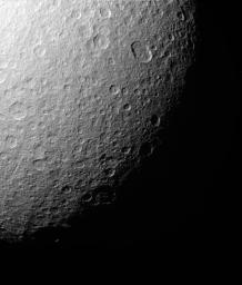
CICLOPS has released this view of Rhea's south polar region. Unlike Enceladus' polar region, Rhea's is heavily cratered. The largest crater in this view is an 115x90 km wide impact crater toward the upper right. There are very few features in this scene that suggest an endogenic origin. An odd gash can be seen at left.

This image was taken on July 14 and has a resolution of 1 km/pixel.

Tuesday, August 16, 2005

Titan Features Receive Provisional Names

Goodbye "Great Britain", hello Shikoku Facula. After more than a year of using nicknames for features on the surface of Titan, features on the surface are now recieving official names. For almost 6 months, the only features that had provisional names were Xanadu, the bright region in the equatorial leading hemisphere, and Ganesa Macula, a possible pancake-dome volcano found by RADAR last October. Now a number of features seen by ISS over the last year have been given provisional names by the IAU. The process began in May when features were selected as important enough to receive names and a proposal was submitted to the IAU, the body that governs astronomical nomenclature. The process was hampered by the same problems that plague scientists, without the support of detailed compositional and topographic information on many of the features that need names, we are left with just albedo markings, which can often be ambiguous at best. So classifying features under many of the existing nomenclature categories was difficult. Such ambiguities led to the creation of several new terrain type, such as virga, which pertains to a streak or stripe of color.

Among the highlights of the new feature names include:
  • Shangri-la, the dark region west of Xanadu
  • Shikoku Facula, the "island" shaped like Great Britain in central Shangri-la
  • Mindango Facula, the "island" shaped like Ireland in central Shangri-la
  • Adiri, a bright region between Shangri-la and Belet, Huygens landed on the western tip of Adiri, the T8 SAR swath will cover the central portion of Adiri
  • Belet, dark region west of Adiri, the T8 SAR swath will cover the central portion of this dark region
  • Ontario Lacus, the "lake" from June
  • Mezzoramia, jrehling's drainage region
  • Omacatl Macula, dark streak north of the "H"
The "H" feature itself doesn't appear to have a name though the southern portion appears to be named Aztlan. The large bright feature in the east central portion of the H are known as Quivira. The angular island, highlighted in T5, is now known as Coats Facula.

New Titan Image: Dawn at the Huygens Site


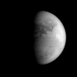
CICLOPS has posted this view of Titan taken last month from a distance of 1.3 million km. This view shows the boundary between Xanadu and Shangri-la. This region was seen a number of times during the Ta, Tb, and T3 encounters and will next be seen upclose during the T8 encounter in October. However, this region has not been seen at this phase angle, providing an opportunity to examine the terrain in this region and its photometric properties. At the time this image was taken, the sun was rising over the Huygens landing site, off the Adiri "coast". The lake-like feature prominently features in images taken in June, Ontario Lacus, can be seen near the bottom, along with a few clouds.

Monday, August 15, 2005

Raw Images of the Day

Space.com article on Enceladus Activity

Space.com now has an article up on their website covering the recent discovery of active volcanism on Enceladus. Not a bad article, nothing new, but it is nice to see space.com cover something other than the Space Shuttle and catch up with the rest of the news.