Friday, August 05, 2005

New Mimas Image: A World of Hurt


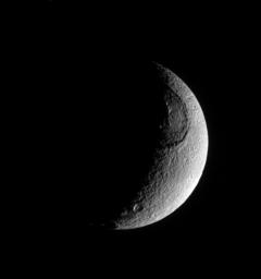
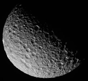
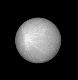
CICLOPS has released this mosaic of Mimas, consisting of three clear filter images taken near closest approach to Mimas. This mosaic is centered near 18.87 North, 238.73 West and has a resolution of 374 m/pixel. This mosaic represents the highest resolution images ever taken of Mimas.

Two prominent features types become apparent in this view. The first are craters. They are everywhere. Clearly, unlike Enceladus, Mimas has had very little internal activity in its history. The surface is so cratered, new craters can only overprint older craters. The craters do show a wide range of morphology due to various states of degradation. While some show signs of internal deformation, or viscous relaxation, which is the dominant form of crater degradation on Enceladus (along with tectonic fracturing), most are degraded by mass wasting. This causes the crater walls to slump down on to the crater floors. This can be seen in most craters larger than 15 km across. The walls on a number of craters are quite tall, up to 6 km in height.

The second prominent feature type are grooves. These features, some over a kilometer deep and 100 km long, maybe caused by the seismic shaking produced by large impacts, like Herschel.

The two largest craters in this view are the 46-km wide Morgan, just above and to the left of center, and the 52-km wide Arthur, near the limb at lower right.

New Mimas Image: Mimas against the Rings


This amazing shot of Mimas was taken during a ride-along with the CIRS instrument. Here you can see a high-resolution image of Mimas with the outer A ring in the background. This image has a resolution of 400 m/pixel and was taken from a distance of 68,000 km.

New Mimas Movie: Flying Over Mimas

CICLOPS has also released a movie showing Mimas as it rotates under Cassini. The movie starts out over Herschel crater and ends up over the highest resolution regions near Morgan crater.

Neat stuf'.

New Mimas Image: Mimas showing False Colors


CICLOPS has released these two processed views of Herschel crater on Mimas. These views were taken from a distance of 228,000 km and have a resolution of 1.4 km/pixel. The view on the left is a clear filter image showing the prominent impact crater Herschel. The appearance of this crater has given Mimas the nickname "The Death Star Moon" (and if I see any more articles or forum thread titles starting with "That's no moon...", so help me...). The clear filter view shows numerous landslides within Herschel, including one on its eastern side, where a part of the crater wall has slid down on to the floor, leaving behind an alcove.

The view on the right is a color ratio image using data from the same time period as the clear filter image on the left. The brightness is the clear filter image while the color comes from a ratio of IR3 - UV3 divided by GRN. We can that there is a color difference between the area near Herschel and the rest of the satellite. This shows up in the clear filter image as a area of brighter terrain surrounded by slightly dark material. This color difference may be due to ejecta from Herschel. But the uneven distribution with respect to Herschel (more bright/"blue" material west of Herschel than north or south) may allude to a different origin. The color differences could be result of changes in composition (if ejecta, material from deeper within Mimas) or due to differences in grain size.

Thursday, August 04, 2005

Mimas Rev12 Images


Just a reminder for posts from the last few days, regarding images taken of Mimas:
Also check out the DEM of Morgan crater (below center in the above images), produced from photoclinometry, or shape-from-shading. These were done by malgar and Bjorn Jonsson over at the unmannedspaceflight.com forum. There is also an anaglyph available.

Present-day oceans on Titan put to rest?

A paper in today's issue in the journal Nature, puts to rest the idea that large parts of Titan's surface are currently covered in methane/ethane oceans. Several years ago, a paper by Campbell et al. in Science, presented evidence for wide-spread liquids on the surface of Titan from specular reflections seen in radar pulses sent from Arecibo. The paper, West et al., in today's issue of Nature uses near-infrared observations near 2 microns. Like Campbell et al. they used ground-based observations to look for specular reflections along a wide-range of longitudes near 25 South Latitude. They found no evidence of specular reflections in their data. Specular reflections at near-infrared wavelengths would be much more conclusive for liquids on the surface than at RADAR wavelengths. For specular reflections to be seen, a surface must be smooth at the scale of the wavelength used to observe the surface. So for RADAR specular reflections, a surface only needs to be smooth on the order of 13 cm (or 3 cm for Cassini RADAR), which can be achieved by such terrain as a mud flat that contains only small, smooth rocks (think Huygens landing site). For a near-infrared wavelength specular reflection, terrain has to be smooth on the order of 2 microns, which is VERY difficult to achieve with anything but a liquid surface. So the absence of a specular reflection at near-infrared wavelengths would seem to rule out liquids at 25 South latitude. The presence of a RADAR specular reflection may indicate that some of these areas are covered in mud flats (or regions without large boulders or rough terrain), perhaps indicating that liquids were present in the past.

There are some pathological cases where you could have a liquid covered in floating crude, but very few materials can float on liquid methane, except perhaps acetylene, but it still has to overcome the low surface tension of methane. Additionally, this study only looked at liquids at 25 South. This leaves open the possibility that liquids may exist seasonally at the poles as they receive enhanced rainfall.

UPDATE: 08/04/2005 12:45pm: New Scientist has a more in-depth article online for those without subscriptions to Nature.

New Tethys Image: Texture of Tethys


CICLOPS has released this processed view of Tethys taken on June 27. This view shows the impact basin, Odysseus, near the dawn terminator at the time this image was taken. Being right on the terminator allows for detailed analysis of the structure of the eastern portion of the basin. For example, one can see a number of massifs near the central peak region and look at the complex layered appearance of the eastern basin rim. This image was taken from a distance of 490,000 km and has a resolution of 3 km/pixel.

Wednesday, August 03, 2005

Next Set of Mimas and Dione images

Mimas Images on Ciclops website

The Cassini Imaging website now has a page of preview images from the Mimas encounter. These are the same images on the JPL raw images page, but without the nasty JPEG artifacts. So be sure to check those out. There is also a map showing intended coverage for the images returned last night and those coming up this afternoon.

Again, the next set of images should start showing up around 1:30pm. Check this site for news and update as they occur throughout the day.

BTW, that's 1:30pm Pacific Daylight Time.

Tuesday, August 02, 2005

Dione, Rhea, and Mimas raw images

Raw images from the non-targeted encounters of Dione, Rhea, and Mimas should start showing up this evening with a second batch tomorrow morning.

Watch this space for raw images as they show up on the JPL Raw images page.
That appears to be it for the night! Come back tomorrow afternoon, around 1:30 pm PDT for more Mimas images.

50,000th Hit and Anniversary

Just noticed that the hit counter went over 50,000 over night, signalling a major milestone for this website. Titan Today has been on the web for only 6 months and has garned more interest than I could have ever expected. I did not design this website for everyone, it was designed for people interested in a little more of the "nitty-gritty" of outer solar system planetary science and the Cassini mission. The fact that so many people visit the site I feel is an indication of the interest in such unmanned missions, missions that continue the human desire to explore, reach out, and see what is beyond that next hill, not necessarily because the valley over might have microbes, but because it is THERE!

Anyways, I also wanted to say Happy Anniversary to my parents! They have been together for 30 years now, absolutely amazing. Congratulations to you both and I hope you have a great anniversary!

Monday, August 01, 2005

First set of images from Mimas Rev12 Encounter

Raw Images from the Mimas Encounter are starting to come down. These early images are from 840,000 km out so these are pretty low resolution, but cover the terrain we will be seeing at much higher resolution one Mimas day later. The large crater at lower left is a 70-km wide crater named Arthur (named after the legendary King Arthur). The smaller crater at about 3 o'clock is named Morgan (~43 km wide).

More images should come down tomorrow and Wednesday.

Also, don't forget to check out this view of Tethys with Odysseus edge-on :=O In case you couldn't tell from this post, the JPL Raw images page has been updated!

UPDATE: 08/02/2005 09:10am: Just a note that images will not start showing up till later this evening PDT.

Rev12 Mimas Encounter


This evening PDT, Cassini will make its closest approach to Mimas for the entire nominal mission. At 9:46pm PDT (ERT), or 04:22 UTC SCET, Cassini will fly within 62,074 km of Mimas' battered surface. This will provide Cassini's best look at Mimas for the entire tour and will provide some of our first decent views of this satellite's south polar region. The south pole of a number of satellites have been highlighted for the last few orbits due to Cassini's currently high inclination. Unfortunately, Mimas is the only major satellite that does not get a targeted flyby in the nominal tour, and unless something major is found during this pass, I doubt it would be a target for one in an extended mission. In addition to Mimas, Dione and Rhea non-targeted encounters are highlighted on this orbit.

Mimas is a relatively small satellite, only 400 km across. Its surface is heavily battered, with numerous impacts filling the surface to saturation. Its near twin in the Saturnian system, Enceladus, has some heavily cratered regions, but even those areas on its surface appear younger than Mimas. Some tectonic chasms can be seen criss-crossing its surface, including one east of Herschel, known as Camelot Chasma, and Ossa Chasma shown above. Unlike Enceladus, where tectonic fractures are likely related to internal heat, fractures on Mimas, given its heavily cratered surface, are likely related to stress caused by Herschel and other large impacts.

This encounter of Mimas will highlight the anti-Saturnian hemisphere of Mimas, particularly the southern regions. At the start of the encounter, Herschel will be near the evening terminator and will cross it and start to go beyond the limb as the encounter progresses. As Herschel pulls out of view, another large crater known as Arthur will pull into view. To the southwest of Arthur is another large central peak crater named Merlin. As we approach Mimas, more of the northern hemisphere comes into view, providing a good look at regions not seen by Voyager and toward a crater known as Morgan. As we pass closest approach we are left with a decent look at the northern reaches of the trailing hemisphere.

Mimas isn't the only world to be highlighted during this orbit. Today, Cassini flys within 206,000 km of Rhea and Dione. Rhea's south polar region, like during the last orbit, should be on full display, but this time the trailing hemisphere will be lit. Images of Dione's wispy terrain could be obtained during this encounter.

UPDATE: 12:35pm: some of the links farther down don't work because Blogger likes to reformat my links. I will try to find a correction... links fixed.

UPDATE: 1:05pm: Björn Jónsson has produced an animation showing the geometry of the Mimas encounter that is definitely worth checking out. The file size is 7MB but is worth the download.

New Rhea Image: Rhea's Bright Blemish


CICLOPS has released this view of Rhea taken on June 25 and was discussed here after it showed up on the JPL Raw images page. This view shows Rhea at a phase angle near zero, meaning the Sun was almost directly behind Cassini's camera when this shot was taken of Rhea. At phase angles that low, little topographic relief can be seen, only albedo variations. This allows such features like the streaks radiating out from a relatively fresh crater seen here to appear so prominently. Craters can be seen despite topographic shading not being visible. Crater walls are often sites of rugged terrain, allowing for more shadowed regions compared to flat areas. So water is preferentially removed from flat, smooth areas, and deposited in areas that are more often than not, in shadow. This process is especially strong on Callisto and Ganymede, where frost from flat areas and slopes that face the equator is removed and is deposited in poleward-facing slopes.

Sunday, July 31, 2005

Planetary Society: Enceladus: South Polar Stripes Spew "Warm" Water

The Planetary Society website has an article by Emily Lakdawalla on the recent discoveries made at Enceladus by the various instruments on Cassini. The article includes information from the three press releases from this past week as well as an interview with deputy project scientist Linda Spilker. The article is a pretty good summary of the results obtained a couple of weeks ago and contains a nice overview of the CDA results that have been discussed here in the comments. Definitely worth reading.