Friday, September 02, 2005

More New Titan Names

The IAU's Working Group for Planetary System Nomenclature (WGPSN) has approved 12 additional names for features on the surface of Titan. These include names for various albedo features on the surface of Titan, including the northern H region. Two additional types of features are included in this round of names, like Arcus (arc-shaped features) and large ringed features, ring-shaped albedo features that are currently thought to be craters. Some of the highlights in this round of naming include:
  • The feature previously nicknamed "Pelopennesos" is now known as Oahu Facula. This feature is similar to the other bright "islands" in Shangri-la, but appears to be connected by a narrow isthmus to Dilmun.
  • The bright, Arc-shaped bright feature, associated with a very bright spot at 5-microns, has been named Hotei Arcus.
  • The feature previously nicknamed "Manhattan" (because it is shaped like a big apple) is now known as Texel Facula. This feature is located at the far eastern end of Antilla Faculae in western Shangri-la.
  • The VIMS "snail", interpreted by the VIMS team as a possible volcano (or cat feces, depending on who you ask), is now Tortola Facula.
  • Several ring-shaped features have been named, including two in eastern Shangri-la near its boundary with Xanadu (Guabonito and Veles) and in north-central Tsegihi (Nath).
  • The northern H region is now named Fensal. A possible name now for the H region as a whole could then be "Fensal-Aztlan"
The USGS site now has a map with names.

Thursday, September 01, 2005

Enceladus Animation

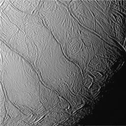
The Photojournal has an animation with a wrap-up of the results from the July flyby, showing both the effects of Enceladus on Saturn's magnetic field as well as showing the great images and fantastic mosaic produced during the encounter. Definitely worth checking out.

Arcus on Titan

The IAU's Working Group for Planetary System Nomenclature (WGPSN) has approved the feature type, Arcus. This term will be used for arc-shaped albedo (possibly topographic as well) features. This feature type would applicable to such features as the "smile", found to be very bright at 5 microns by VIMS.

No word yet on additional names for Titan and this "arcus".

New Tethys Image: Tethys in the Dark


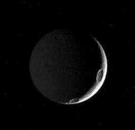
CICLOPS has released this processed view of Tethys taken on August 3, when Cassini was 842,000 km from the satellite. Only a thin crescent was visible of Tethys at the time this image was taken, when the phase angle was 144 degrees. Images like these can be used to study the photometric properties of the surface material on Tethys, particularly with how backward scattering it is. Two good sized craters can be seen along the terminator, or the dividing "line" between night and day. The one at about the 3:30 position is Penelope. The smaller crater near 5:30 is Antinous. While it hasn't been stretched to make it visible, much of the left part of Tethys' disk viewed here is lit dimly by Saturn-shine. This technique, however, requires longer exposure times than those used here to be useful for geologic analysis.

This image has a resolution of 5 km/pixel.

Tuesday, August 30, 2005

Enceladus' Tiger Stripes


A lot of big news today about Enceladus as all the major instruments on Cassini reported their results. Most of the results revolve around the four prominent fractures in the south polar region known collectively as the "tiger stripes". These "stripes" are actually tectonic fractures, 140-170 km long and a couple of hundred meters deep. In the IR3 filter on the Cassini Narrow Angle Camera, sensitive to infrared light around 920 nanometers in wavelength, the fractures are surrounded by dark material lying between 2-5 km on either side of the fractures. When combined with the green and UV3 filters for stretched color images, the stripes appear blue to blue-green. On one of the stripes, a darkish spot, 3 km in diameter can be seen.

To sum up what we have learned today from VIMS, we know that the coarse-grained ice along the edges of the tiger stripes consists of crystalline ice (based on an absorption at 1.65 microns, not seen elsewhere on the satellite), which only forms at temperatures above 110 K. These crystals will degrade over time after cooling below 110 K thanks to the radiation environment, in a few decades up to a thousand years. This is what led to the VIMS teams claim that the fractures are young, less than 1000 years old, maybe even 10 years or younger. However, they are basing this on compositional evidence of the crystallinity of the ice. The crystalline ice could be ice brought up to the surface after the most recent eruption, not necessarily signalling that the fractures themselves are 10-1000 years old (though we couldn't rule it out, no craters larger than 400 meters or so have been found south of 70 degrees south latitude). VIMS also found simple organics along the fractures with a similar distribution of crystalline ice, based on an absorption at 3.44 microns.

So how did that material, crystalline ice which requires relatively warm temperatures (> 110 K), which appear to have coarse grains based on other VIMS measurements and ISS color spectra, and simple organics get there? INMS, as mentioned below, measured mostly water vapor above the south pole, along with N2, CO2, Hydrogen, and 1-2% CH4 and C2H2. So one could envision the plume scenario powered by a water-ammonia diapir almost directly below the south pole, where water vapor escapes from fresh fractures in the crust. The material with the lowest energy will be deposited just adjacent to the fractures and the material with higher energies will form a plume and then a transient, patchy atmosphere. So far, no nitrogen-bearing compounds in spectra of Enceladus and only hints of CO2 have been observed. But still, depsosition from a plume, rather than sublimation of fine-grained, amorphous ice seems reasonable. It is possible, though, that surface ices bordering the warmer fractures were transformed into crystalline, coarse-grained ice from the heat coming from the fractures. However, the simple organics, found no where else on the satellite (in fact the spectra of the rest of the satellite mirrors laboratory-quality water ice), would still need to be explained.

Even More Enceladus from the BBC and New Scientist


New Scientist and BBC News both have fantastic articles on the press conference today in London on Enceladus. Both cover similar results from the two press releases, but both do mention that VIMS found simple organic compounds along the tiger stripes (shown above) in addition to crystalline ices. This may confirm the marginal detection of methane in the INMS mass spectra. No word yet what the simple organics are. I'm trying to find out as I type this. The New Scientist articles does go into speculation that the boulders seen by ISS at very high resolution may be lava bombs, but such a mechanism may not be necessary given the intense tectonic reworking of the region. Torrence Johnson is quoted as saying, "They are awfully large, but Enceladus' gravity is weak, so it doesn't take much to lift stuff off the surface".

Major Eruption at Enceladus?


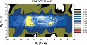
In the first half of 2004, as Cassini approach Saturn prior to SOI, UVIS detected a dramatic increase in the amount of atomic oxygen in the Saturnian system, centered near the orbit of Enceladus. At the time of the announcement, the increase in mass in the region, roughly equivalent to the total mass of the E ring, was attributed to the collision of two km-sized particles in the E ring. However, the UVIS principle investigator, Larry Esposito, stated at the CHARM telecon today that "the water vapor escaping from Enceladus is adequate to supply the atomic oxygen in the Saturn system detected by UVIS, and to re-supply Saturn's E ring." So, what do we make of these two pieces of data, the likelihood that Enceladus supplies the atomic oxygen in the Saturn system and this dramatic increase in atomic oxygen last year. The obvious mechanism would be a major eruption on Enceladus. During this eruption, tremendous amounts of dust and water vapor was pumped into the E ring and the Saturn system. Certainly a very interesting idea that hopefully the UVIS team is examining.

"Enceladus Eruptions" CHARM presentation

Today's CHARM talk covered the UVIS results at Enceladus from the flyby last month. I've linked to the PDF file with the slides from the talk above. This talk fit nicely with the press briefing today since it perfectly covered many of the discoveries announced at the talk plus providing more in-depth analysis of the data as well as...more graphs. UVIS detected an atmosphere on ingress of the gamma Orionis occultation in July but failed to detect an atmosphere during the occultation in February. The path of the occultation allowed for measurements at a far southern latitude on ingress, allowing UVIS to measure the patchy atmosphere measured by MAG and INMS. UVIS was able to detect the atmosphere starting at an altitude of 155 km above the surface of Enceladus using the High Speed Photometer (HSP) on UVIS. Compositionally, UVIS found that the atmosphere/plume was made primarily of water vapor with no detection of CO (thus placing an upper limit on CO at 2x1014 cm-2. This is important because INMS detected a species at mass 28 which can either be CO or N2. N2 could be a disassociative product of ammonia in Enceladus' patchy, slushy interior.

In addition to the UVIS data, the talk, by Larry Esposito the UVIS Principle Investigator, also has data from INMS, with a plot of their data from below 500 km. The plot shows a high number of counts from H2O and less amounts from a species at mass 28 as well as hydrogen and maybe methane. The detection at mass 44 is a mix of background noise and CO2. The presentation also has plot from the simulation the CDA team ran to show that their data was consistent with a spread out source near the south pole.

Esposito concludes by stating that the composition of the atmosphere is mostly water vapor with a near surface abundance of 1.5 x 1016 cm-2 with an upper limit on CO at 2% the water vapor density. The atmosphere is not global and has only been found near the south pole. Finally, and here is the kicker as I will go into with more detail later today, "The water vapor escaping from Enceladus is adequate to supply the atomic oxygen in the Saturn system detected by UVIS, and to re-supply Saturn's E ring."

Update 12:45 pm: The detection at mass 44 is a mix of background noise and CO2. Not sure what the mix is, but is less than the detection at mass 28...

More on Today's Enceladus News


As mentioned in the last post, the ISS, CIRS, INMS, and CDA teams worked together to produce a plot showing the locations of peaks in temperature, water vapor, and dust on a polar projection map of the surface of Encleladus. At first glance, the peaks for INMS and CDA would seem to suggest that the circumpolar ring of folded, tectonic terrain may be the source of the vapor and dust. However, neither peak is located within the region of warm ice seen by CIRS, an area that would be more likely to see significant activity. Numerical simulations by the CDA team, combining the timings of the CDA and INMS peaks, suggest that both the vapor and the dust are connected, have the same source, and are distributed across a small region on the surface near the south pole. The source is not impact-generated dust which would be uniform across the surface, as originally thought.

So what does this say about how the vapor and dust form? Three possible scenarios were presented at the press conference. The first scenario sugggests that sublimation of ice within warm, 140 Kelvin fractures, could produce the vapor. This would fit with the lack of a visible plume by ISS but may not fit with the dust detections. The dust could possibly be produced by condensing vapor, but this may not be supported by the CDA data. The second scenario suggests that vapor and dust are generated by a plume that eruptions along the tiger stripe fractures. This would easily allow both vapor and dust to be ejected to the altitudes seen by INMS and CDA but thus far, no plume has been observed by ISS. The third scenario suggests that vapor and dust could be produced by sublimation along cryolava flow fronts. While some of the terrain between the tiger stripes looks like a lava flow, the distribution of crystalline ice seen by VIMS and the blue-green course-grained ice seen by ISS have been observed along the fractures, not within the flows, so it seems that this scenario may not fit the current conditions. My only complaint about the graphic is that it assumes that the interior is made of only water, not water mixed with ammonia, which would lower the melting point of water. I don't see why you can't have the plume scenario with a sub-surface layer of water mixed with ammonia (just to answer Jerry's comment about the required temperatures).

So which scenario are scientists leaning toward? Considering current conditions and what we have observed geologically, I would definitely lean toward the second scenario for a few reasons. While we have not observed a plume, there are some indications that activity at Enceladus may be quite variable. UVIS detected a large increase in the amount of oxygen in the E ring early last year. Considering that the primary source of the E ring is now found to be the south polar vents, it seems reasonable that such a mass increase could have been due to a major eruption on Enceladus. Such variability with time may be difficult to achieve with the first scenario. Plus, one has to consider how you get dust particles along with the vapor in a purely sublimation scenario. You can do it, but I find it hard to believe you can do it with this much dust. The third scenario could partially fit, the terrain between the tiger stripes does look an awful lot like a lava flow. However, the distribution of course-grained ice, the sublimation problem mentioned in the first scenario, and the lack of ammonia detected on the surface seems to suggest that the cyroflow sublimation model is not the best fit. So I would consider the second model, the plume model, as the best fit to the data.

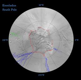
The ISS team also released preliminary tectonic maps showing the distribution of longitudinal and latitudinal fractures on the surface. These maps show that many of the fractures on Enceladus follow longitude and latitude lines, perhaps caused by the changing shape of Enceladus as the tidal stresses on Enceladus wax and wane. In addition these maps outline a wavy, circumpolar ring of fractures at around 55 degrees South latitude, marked by Y-shaped discontinuities that lead into fracture systems that lie along lines of longitude. Such fractures could be caused by "hoop stresses", formed during periods when the equator expanded, perhaps as Enceladus was sped up. Unmarked versions of these maps of the north and south polar region show the marked difference between the two polar terrains. The north polar region is heavily cratered and is the oldest region on the surface of Enceladus. The south polar region is very young with very few craters south of 55 degrees south, and none (larger than 200 meters) south of 70 degrees south. Note the hooks at the end of the tiger stripe fractures.

More Enceladus to come.
Tiger Stripes on Enceladus found to very young and active


At a press conference in the UK at the Cassini PSG (Project Science Group) meeting, additional details from the July flyby of Enceladus were revealed. The briefing focused on the cryovolcanic activity observed in the south polar region observed by a number of Cassini's instruments, including ISS, VIMS, CIRS, INMS, UVIS, and CDA. There is a lot of ground to cover on this and I will be posting several times today on this story.

First, INMS and CDA observed asymmetries in their data that have been plotted on a graph as well as shown on a polar projection map of Enceladus with the ground-track and the locations of the CDA and INMS peaks, and the CIRS hotspot, indicated. Previously, CDA reported that their data was consistent with impact-generated dust, not from endogenic activity. If you look at the graph, it is pretty close to a bell-shape curve, which is what you would see in an impact-generated dust scenario. However, the curve is shifted in time from closest approach, with the peak occuring 70 seconds before C/A. In the impact-generated dust scenario, the peak would be right at closest approach, so this shift would not be consistent with that scenario, but with one where dust is ejected up to a certain height from a volcanic vent. So it now appears that the south polar region of Enceladus is the source of the very small particles in the south polar region. UVIS data from two star occultations in February and July also seem to suggest that the "atmosphere" produced by the venting of water vapor and micron-sized dust is not global and localized to the south polar region.

VIMS was also at the press conference, showing a view of the surface of Enceladus taken by their instrument. This image shows the distribution of crystalline ice on the surface, which under Enceladus conditions quickly degrades to amorphous ice. VIMS found that there was quite a bit of crystalline ice in the area surrounding each fracture collectively known as the tiger stripes (because of their appearance and the way they standout in the normally very bright south polar region). Considering the conditions at Enceladus, crystalline ice is expected to convert to amorphous ice over a period of several decades so geologic activity along the stripes must have occured between 10 and 1000 years ago (though more recent episodes are certainly possible, and likely, as I will discuss in a post later today).

In my next post, I will discuss the ISS releases as well as the possible models for activity.

New Rhea Image: Tirawa at Twilight


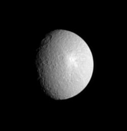
CICLOPS released this processed view of Saturn's moon Rhea today. This image was taken on August 13 from a distance of 2 million kilometers and has a resolution of 12 km/pixel (though the processed view has been magnified by two times to aid visibility). This view of Rhea is centered just west of a prominent ray crater on the surface of Rhea. Near the terminator, to the northwest, is a 360-km wide impact basin known as Tirawa. Based on Voyager measurements, Tirawa is 5 km deep.

Monday, August 29, 2005

Off-topic: Hurricane Katrina


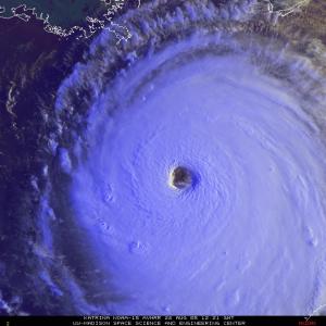
A bit off topic but I have just been mezmorized by the coverage today of this hurricane. Thankfully, New Orleans was spared the worst, but still there is going to be a lot of cleanup related to this storm, particularly in eastern New Orleans, Biloxi, and Gulfport. My prayers go out to those in that area and hopefully all those in the effected areas will be safe. Now for some links:
Update: 09/02/2005 11:40 am: Obviously, since I wrote this post, the situation in New Orleans has deteriorated. Those in Katrina's desperately need your help. I urge those reading this blog to donate to the American Red Cross. You can easily donate using Yahoo's Red Cross page.