Friday, June 10, 2005

New Small Satellites Images

There are some new raw inner satellite images now available, including the best images yet of Atlas and Pallene. Atlas is the big winner here with a huge equatorial ridge. The image of Pan also shows a ridge around its equator. It has been suggested that Iapetus' equatorial bulge might be due to infalling ring material. I don't agree with that hypothesis for Iapetus, but for Pan and Atlas (both embedded within ringlets and Pan within the Encke Gap of the A ring), that theory might work.
In addition, the first set of Hyperion images is now online.

New Atlas Image: Embedded Atlas


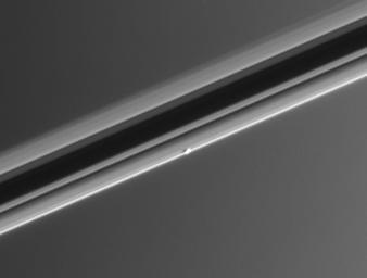
CICLOPS has released this low resolution view of Saturn's inner moon Atlas. Atlas, a small moon only 32 km across, orbits just outside the main A ring of Saturn. This view also shows the ring system of Saturn, against a backdrop of Saturn's atmosphere, nearly edge-on. The resolution of this image is 5 km/pixel though the image has been magnified 2x to aid visibility.

Thursday, June 09, 2005

New Dione images

New Dione Images are online at the JPL raw images on their Cassini site, just search for Dione. Some of the newest images are still not fully ingested (from a 2x2 full-color mosaic), so dig in a page or two. The link above takes you to a full disk image of Dione. The view shows the south polar region, Cassandra (the ray crater), and the region south of Padua Linea (bottom left) and Palantine Linea (right, just sunward of the terminator). Here you can see incredible relief in Palantine and albedo in Padua (as well as the UV dark material). What surprised me is the 350-km wide basin at upper left (size is just a guesstimate, don't quote me on that). So Dione has a giant impact basin like Tethys near the south pole. Also note the high mountain along the limb near the basin. Finally, observe how smooth Dione is, between craters.

Update: 06/13/05: Wow, I am getting really good at this. The basin is 350 km across.

More on the VIMS Snail (or Titan Volcano)


Released yesterday by the VIMS team after I had gone home for the day, is this mosaic of images taken during the TA flyby in October of the "snail" feature. Resolution in this image varys from 2.6 km per pixel for the background image to 1.8 km per pixel for the higher resolution image.

In other "Snail" news, the Astrobiology magazine has an article on the feature, largely based on the press release associated with the Nature letter. There is, however, a great quote from Ralph Lorenz, a member of the Cassini RADAR team:

"It might well be a volcano, but it would be hard to say for sure without RADAR data," says Lorenz. "It looks as much like a giant cat poo as it does a volcano."

I, um, couldn't have said it better myself.

New Cassini Image: One View, Multiple Worlds


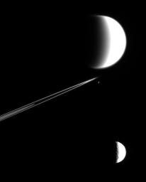
CICLOPS has released this processed opnav images showing Titan, Tethys, and Epimetheus. Titan and Tethys are washed out here because the original image was overexposed. During ring-plane crossings, it is not uncommon for Cassini to view multiple satellites in the same narrow-angle camera field-of-view, as seen in several other previous images. Don't let the apparent sizes of the moons in this view fool you, Titan was more than twice as far away from Cassini when this picture was taken than was Tethys.

Wednesday, June 08, 2005

VIMS images of the "Titan Volcano"


What the?!? There really going with the "volcano" story on this one. Every one of the titles for the "snail" says this is a Titan volcano. Then again, I might be doing the same very soon...

Anyways, VIMS has released a set of spectral maps of the "Snail", a geologic map, and a map made of VIMS images.

VIMS Titan Paper in Nature

The VIMS Nature paper on results from the Ta flyby is now out. They examine a feature they have been calling the snail as well as the surrounding dark terrain, seen in data taken during Ta with resolutions approaching 1.5 km/pixel. Based on spectral and geomorphologic analysis, Sotin and his VIMS collaborators interpret the snail as an ice volcano, within an area of extensional tectonics. The dark region it is in is interpreted as being filled with ridges and valleys, based on photoclinometric analysis of bright and dark banding within the dark terrain.

I'll come right out and say it, I have serious reservations about the interpretations (particularly the photoclinometric analysis) as well as the lack of mention of the other optical instrument that can be used for Titan geology. First, the interpretations: the bright and dark banding in the "snail" image is interpreted by the VIMS team as due to ridges and valleys with a wavelength of 10 km. This goes against what RADAR sees within dark terrain and what ISS sees. RADAR has seen no evidence of ridge and trough terrain on that scale, though they have seen dunes at a much smaller scale. Doesn't mean that such terrain doesn't exist at the snail's location, but it does form reasonable doubt in my mind. Second, ISS sees plenty of albedo variation within the dark terrain that is NOT caused by topography because we can't see it. How would this be any different (photoclinometry uses, as its starting assumption, that there are no albedo variations within the area in question)? I'm not saying that this isn't possible, but I think the VIMS team is reaching.

I do like the idea of the ice volcano. Not saying I completely agree, but it's nice to see they are taking a shot at interpreting what would cause the spiral structure. Louise Prockter's suggestion that it might turn out to be a crater is a valid point to make, but I don't think it fits the observations here (given our observations of other craters).

A few links are in order here. The paper is by Sotin et al. There is also a news item by Louise Prockter on this paper and gives a more outside perspective on the results within. A subscription is required to view these papers, but if you shoot me an email and ask very nicely...
Tuesday, June 07, 2005

Second Set of Titan Images Online


The second set of Titan images from yesterday's non-targeted encounter of Titan are now online. These images highlight the south polar region of Titan, very similar to the encounter shortly after SOI. The image above shows the best image from this pass of the south polar region. Among the highlights include a scattered cloud field throughout the upper left part of the image and curious dark albedo patterns near the south pole. The south pole was covered by clouds during the T0 pass. These dark markings, particularly the peanut-shaped feature to the lower right of the dark patches, may indicate the presence of liquids on the surface. Maybe...

Other images from this set include:

New Rhea Image: Sun-Drenched Rhea


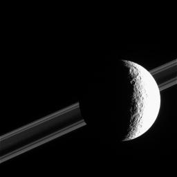
CICLOPs has released this view of Rhea taken in February. While much of Rhea is over-exposed in this view, craters and impact basins near the terminator are clearly visible. Saturn's rings can be seen in the back ground. The resolution of this view is 3 km/pixel.

Monday, June 06, 2005

New Rhea Image: Rhea's Bright Splat


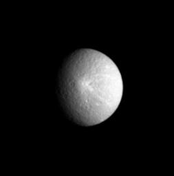
CICLOPS has released this processed view of Saturn's moon Rhea, highlighting a ray crater on the satellite. This ray crater was seen in a higher resolution image released a couple of weeks ago. This image has a resolution of 12 km/pixel and was taken on April 27. This view shows Saturn's anti-Saturnian hemisphere.

First Set of Titan Rev09 Images Online


The first set of Titan images from today's flyby are online. These images are taken on Saturday and range in resolution from 9 km/pixel down to 6.8 km/pixel. An early look at this observation shows a cloud near 75S latitude in all the CB3 images. Very few clouds have been observed on Titan in the last 6 months so it has come as a surprise to find one now. It is also personally disappointing since I had hoped to have at least one observation for the entire south polar region that was cloud-free. The south pole is clear, so I can use this and hopefully images to come from this non-targeted encounter, but it will be more patchwork-y than I had hoped.

Sunday, June 05, 2005

Updated Maps

Steve Albers has updated his Mimas and Enceladus maps to include additional Cassini data. In the Mimas case, a frame from January was added. For Enceladus, the image of the south polar region taken a couple of weeks ago was added. Steve's maps are definitely some of the best available online so they are definitely worth a look.