Saturday, February 19, 2005
Friday, February 18, 2005
Press Release: VIMS Finds No Ammonia on Enceladus
Other preliminary results from the visual and infrared mapping spectrometer show a surface composed of only pure water ice, with no other compounds detected. Ammonia or ammonium compounds and carbon dioxide were expected, but not seen in the data. Further analysis may find trace amounts. "The spectra look like laboratory fabricated water ice, indicating the ice is quite pure," said Dr. Roger N. Clark, Cassini science team member at the U.S. Geological Survey in Denver.Thos definitely puts a monkey wrench into theories on Enceladean geology.
New Enceladus Images: Enceladus at High-resolution and 3D
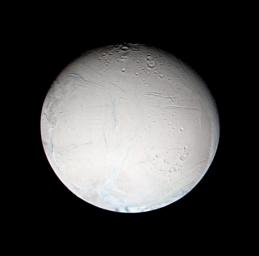
CICLOPS has released some processed views from the non-targeted Enceladus flyby. The image above is a false color view showing color variations between the ridge and trough terrain and the surround surface. These variations suggest that the ice in the canyons maybe fresher (either through smaller grain size or less non-ice contamination) than the rest of Enceladus. Other images released include a 4-image mosaic showing anastomosed fractures near the limb of Enceladus, an anaglyph showing 1-km tall ridges, and a framelet showing a chevron-ridged band of terrain covered in "leopard-spots".
Press Release: Titan's Atmosphere Comes from Ammonia, Huygens Data Say
Cassini Significant Events 02/10/05 - 02/16/05
RADAR SAR Movie
RADAR SAR Hills
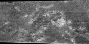
This is third RADAR SAR image released today. This area appears similar to the region seen in SAR coverage in October. While the title of the release is "Dark Terrain", in ISS images, this area seems to be of intermediate brightness, neither dark, like the region west of Xanadu and the "H" (north and east of Xanadu), not bright like Xanadu and the region surrounding "Circus Maximus". This image shows a number of hillocks and ridges surrounded by RADAR dark terrain. The subtle bright features maybe cryovolcanic flows, similar to those seen in October.
RADAR SAR Landing Site Analog
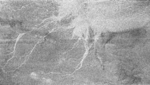
This image is one of three RADAR SAR views released today from this week's flyby. Here is a portion of the caption:
This area imaged by the Cassini radar system during the spacecraft's third close flyby of Titan on Feb. 15, 2005, is just to the east of the Circus Maximus impact feature (see http://photojournal.jpl.nasa.gov/catalog/PIA07365).Another support for the rubble strewn plains is that the intermediate brighness region with the channels is bright in ISS images while the really bright radar region is dark in ISS images, which would be the same relationship in DISR images.The white lines could be channels in which fluid flowed from the slopes of Circus Maximus toward the bright area in the upper right. Areas that appear bright at radar wavelengths may be rough or inclined toward the direction of illumination. The bright area in this image could have received outflows of debris from the channels, making the surface appear radar bright. In this sense, the area may resemble somewhat the rubble strewn plains in the region where the Huygens probe landed. The fluid carrying the debris was most likely liquid methane, given the extremely cold ambient conditions at the surface of Titan.
The longest channel in the feature is approximately 200 kilometers long (124 miles). The seams running across the image are an effect of the matching of the different radar beams to assemble the full image.
60-km Crater found by Radar

This is one of three new RADAR SAR views released today (taken during this week's Titan flyby). The image shows a relatively fresh 60-km wide impact crater to the northeast of the "H". The caption explains that the bright region that surrounds that is caused by ejecta from the crater though comparisons with images to be taken of the region on March 31 will be needed to confirm this, IMHO. Though not explictly called out in the image, this view shows another bright/dark boundary with "cat-scratch" ridges. The dark terrain is part of a feature known as the "H" because it is shaped like the letter "H" (though it was later found to be connected to a circular dark region with the giant crater in the radar image released earlier near the center.
Also note the bright islands to the lower left. These appear to be similar to those seen by ISS in the dark terrain west of Xanadu and in the landing site region. Like the features seen by ISS a half a world away, the islands have diffuse aprons that generally trail the island to the east, suggesting these aprons are cause by winds blowing material away from the surface of the islands (rather than liquids, though liquids could have done the initial eroding).
Thursday, February 17, 2005
T3 Global Mosaic

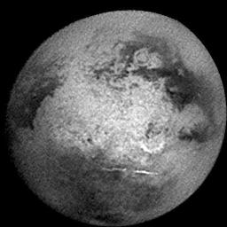
CICLOPS has released the image I worked on for over 12 hours on Tuesday. This is a mosaic of 16 images, each with a scale of 1.4 km/pixel, taken Monday by the Cassini ISS instrument. Interesting features are seen through out this area of the surface, like the "islands" within the dark terrain, the chaotic terrain of the bright material, and the two lonely clouds near the south pole. I know, this is the same hemisphere as the last two flybys, but this will be our last trip here for a while so don't take it for granted.
Compare this view with the last global mosaic.
New Titan images

CICLOPS has released a series of image products from Tuesday morning's T3 Titan flyby. Here is a list of those products:
- Hazy Days on Titan . This is the color view above.
- A Clear View of Titan's Surface
- On Titan's Nightside
Wrinkles, Flows, and Leopard Spots, Oh My!!
- Bifrucating ridge at 70 m/pixel
- Cryoflow with leopard spots?
- Europan-style terrain cross-cut by new, deep fracture
- Another cryoflow?
- Mirandian style terrain on right
- Okay...I'm lost, but that's a good thing
Wednesday, February 16, 2005
Enceladus Raw Image posted
Titan Radar Image: Multi-Ring Impact Basin

Here is a RADAR image showing what appears to be a giant impact basin on Titan. This basin, 440 km wide using the outer diameter, is one of the first definitive craters on Titan. Previously, no craters had been found, or if a circular feature was found, a different origin was found to be more likely (viscous volcanism or calderas). The circular feature seen here has been by ISS and can be seen as the bright/dark annulus toward the upper right in the image below.
Titan Radar image: Cat Scratches
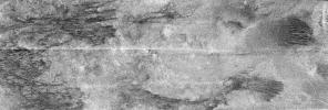
This is a new view from Cassini RADAR showing, what to me, looks like pull-apart terrain, as if the terrain is being run through a cheese grater. This view is just to the west of the mult-ring impact basin shown above. One interesting feature to note is the meadering bright channel in the lower right hand side of this observations. Dry river channels maybe?
1st Enceladus Image posted
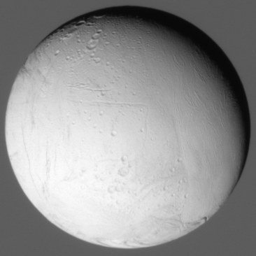
The first of many Enceladus images to come has been posted on the CICLOPs website. So far, the view is very impressive. This first image, part of the GEOLOG001 sequence, shows the craters Dunyazad and Shahrazad near the terminator. Harran Sulci can be seen to the lower right of those craters. Saturn is seen in the background.
Update:
Try this from GEOLOG002. :o Look at the terrain near the lower left.
T3 Image: North Polar Haze Layers

These haze layers near Titan's north pole, in an image taken Monday, are really impressive. My favorite "atmospheric" frame thus far in the Cassini mission.
New Keck view of Titan

Antonin Bouchez's group at Berkeley and Keck have released a new view of Titan taken at the Keck Observatory in Hawaii yesterday. The view also shows a lack of clouds in the south polar region. In addition to posting this new image, the group has also compiled their data sets in to color composites, showing surface and atmospheric features at ~2 microns in one view.
New Mimas Image: Outsider Moon
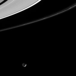
CICLOPS released a newly processed view of a crescent Mimas and Saturn's A and F rings. A very pretty shot :-D
A color version can be found here.
Near-IR Spectrum from Huygens

ESA has released a plot, shown above, of the near-IR spectrum of Titan taken by Huygens from three heights: 150 km, 500 m, and 20 m. The last altitude had the lamp on and mostly represents the spectrum of the surface, not the combined spectrum of the atmosphere and the surface. The spectrum at 500 m is darker due to the increased methane absorption at lower altitudes, and the fact that the 150 km spectrum was taken over a bright region, as opposed to the 500 meter spectrum. Nothing major really jumps out though many of the non-methane related features are consistent with water ice.
Tuesday, February 15, 2005
More T3 Raw Images
New Keck view of Titan

Antonin Bouchez's group has posted a new image of Titan showing their view of the surface from the other night. Compare the view above to the approximately concurrent view from Cassini.
First Set of T3 Raw images posted
Monday, February 14, 2005
Planetary Society T3 Preview Article
Press Release: Scientists Release Audio Huygens Sent During Titan Descent
DISR Flat-field
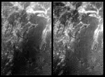
Above is a before and after shot showing the effects of using a flat-field filter on DISR images. The image shows the MRI (middle image in triplet) from Triplet 535. An HRI example, using the bottom framelet in triplet 404, can be found here. In both examples, original image can be found on the left and the flat-fielded and noise-filtered image is on the right. The TIF-format flats I used along with a short explanation of how I created them can be found in the zip file here. Flat-fielding can be accomplished in many astrophotography software packages, like Giotto. Flat-fielding is important for removing CCD artifacts like variations in pixel sensitivity which can cause gradients to appear in digital images. In the MRI flat, the brighter region along the tops of each images is removed, for example.
Rene Pascal, who created the wonderful mosaic highlighted below, got me thinking about DISR flat fielding and has posted a detailed explanation of how he processes these images along with the MRI flats he uses on his website. He doesn't have an HRI flatfield, but his work on the MRI flatfield was much more analytical than mine.
T3 Coverage Plot

CICLOPS has released a figure showing the coverage that ISS will obtain in this week's Titan flyby. The blue outline represents the area where ISS will get coverage with resolutions of at least four kilometers per pixel or better. the green outline represents the area where ISS will obtain coverage with resolutions of at least 1 kilometer per pixel. The red outline represents a frame where we will get coverage of at least 700 meters/pixel. Finally, the yellow outline represents two footprints where we will get high resolution coverage of at least 200 meters/pixel.
The surface science goals of the flyby are to search for changes in this area since we have imaged it twice on the previous two Titan flybys (not including the Huygens drop flyby last month), to look for a specular reflection by comparing images taken this week to those taken during those prior encounters, to understand the bright/dark boundary in northwestern Xanadu, and to compare ISS high resolution images to both RADAR SAR and altimetry data taken on this encounter. The western yellow outline is the footprint for the altimetry comparison and the eastern yellow outline is the footprint for the SAR comparison.
For an idea as to where the RADAR SAR swath will be located, check out the Stofan et al. abstract for this year's LPSC.
Coverage Plot for this week's Enceladus encounter
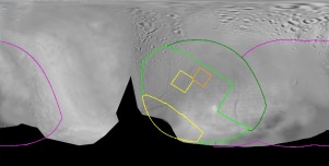
CICLOPS has released a coverage plot showing where ISS footprints will fall on Enceladus during Cassini's encounter this week. The highest resolution coverage will fall in places seen by Voyager at around 1 km/pixel. These higher resolution images will help us understand how the smooth terrain and grooves formed on Enceladus and whether their formation process still occur today. One particular aspect to look out for is small craters. We know most of these smooth areas are relatively devoid of craters at the 2-10 km size and greater, but do smaller craters exist. Finding out would greatly help scientists interested in Enceladus to know how old the surface is.
Sunday, February 13, 2005
Low-Res raw Titan Images Posted
To look at the new images, go to the JPL Raw images Page, tap on Titan in the target list in the search area on the page, and search for images. The first 22 images are in the latest sequence.
